On a Saturday afternoon this summer, I walked from West Jerusalem to East Jerusalem. West Jerusalem was a ghost town, everyone celebrating the Sabbath with their families: no cars, few pedestrians, shops and restaurants closed. Buses don’t run. Really, it was spooky. You cross a street and come to East Jerusalem: a bustling city with teeming crowds, shops spilling out onto the sidewalks, traffic jams. There’s no wall or sign, but suddenly it’s a different world.
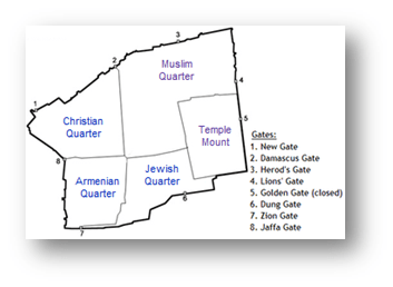
Jerusalem is a divided city within a divided country (or two countries, depending on who you ask) and there’s even a divided city within it: the Old City, which has four quarters; the Jewish Quarter, the Christian Quarter, the Moslem Quarter, and the Armenian Quarter.
A week later we were in Berlin, which of course did have a wall, and where hundreds of people were shot trying to get from East to West. Today, twenty years after the wall came down, the city is seamless. When they merged, the East lost its identity, except for the Ampleman, the beloved traffic crossing figure which they fought to save.

There are “Places Where People Like Me Live” and “Places Where People Who Aren’t Like Me Live”.
There are places where we go and where we don’t, as shown on this fold-out map of Paris. The colors show “where I go” and ‘where I don’t go” (“J’y vais, J’y vais pas.”)

You don’t have to travel far to find a divided city. Check out these beautiful but sad maps, produced by Eric Fischer, showing the racial distribution of US cities (White population shown in red, Black population shown in blue):

San Francisco Bay Area

New York Metropolitan Area

Detroit
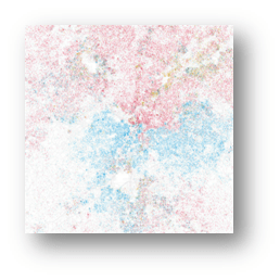
Atlanta

Chicago
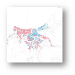
New Orleans

David the divided City is a bit disapointing.Maybe you meant it to suggest more thought be given by the reader as to how the residential divisions in major US population centers might divide the individul centers. Clearly one would have to look at both residental patters and other patterns such as major employment areas, retail centers, and nightlife and major thoroughfares and transit routes. All of which may bidge the walls. Examples in San Francisco might be Tenderloin percieved crime probably deters some from entering, but the I’m not sure the white majority in the Marina or Castro deter entrance by non whityes to eventgs that occur in that area or mingling with the residents at restaurants etc.
Since San Francisco is regularly called out for having few children, I asked Mr. Fischer to use the same census data to map out where the kids are in the Bay Area. Mr. Fischer was kind enough to run the data and produce this map: